Home / Totsukawa and the Kohechi trail
Totsukawa Village and the Kumano Kodo Kohechi
At the southern tip of Nara Prefecture, Totsukawa Village covers 672 km², larger than Lake Biwa or Tokyo's 23 wards: the biggest village in Japan. 96% of it is forest, and the Totsukawa River flows along the bottom of deep valleys. From ancient times to the end of the Edo period, whenever turmoil struck the capital, the people of this mountain-locked village came down from the hills and rushed to help.
World HeritageSacred Sites and Pilgrimage Routes in the Kii Mountain Range (2004)
Labels: Factdocumented Likelysupported by most sources Legendoral tradition Urban legendlocal lore and rumour
Japan's largest village
FactTotsukawa Village covers 672.38 km². Excluding the villages of the Northern Territories, it is the largest village in Japan. Its population is about 3,000, and its hamlets are scattered along valleys and on mountainsides. It takes more than three hours by car from Nara City, and Japan's longest local bus route (Yamato-Yagi Station to Shingu Station, about 170 km) runs the length of the village.
The Tanize Suspension Bridge: 8 million yen from the villagers
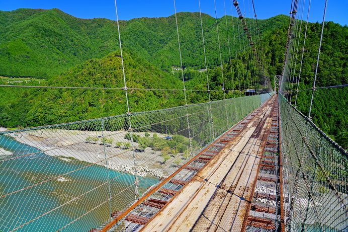
FactThe "Tanize Suspension Bridge", linking the hamlet of Tanize with the opposite bank, is 297 m long and 54 m above the river. It is one of the longest steel-wire suspension bridges for everyday use in Japan. Until 1954 there was only a log bridge, and the hamlet was cut off every time the river rose. That year the residents put in 200,000 to 300,000 yen per household and paid most of the 8 million yen total cost themselves to build the bridge. This was at a time when a university graduate's starting salary was less than 10,000 yen.
FactThe bridge is still a road for residents' daily lives, and visitors may cross up to 20 at a time. You can see the bottom of the valley through the gaps in the boards underfoot, and it sways with every step.
Kumano Kodo Kohechi: from Koyasan to Kumano
FactOf the "Kumano Kodo", the pilgrimage routes to the Three Grand Shrines of Kumano, the "Kohechi" is the shortest route between Koyasan, the holy mountain of Shingon Buddhism, and Kumano Hongu Taisha. About 70 km long, it crosses three passes over 1,000 m high, Obako, Miura and Hatenashi, making it one of the toughest routes of the Kumano Kodo, and much of it runs through Totsukawa Village. In 2004 it became part of the World Heritage site "Sacred Sites and Pilgrimage Routes in the Kii Mountain Range".
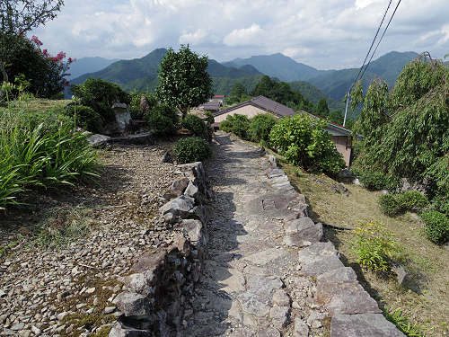
FactThe hamlet of Hatenashi, just before the Hatenashi Pass, has houses lined along a stone-paved path and is sometimes called "the village in the sky". Along the path, stone Buddhas carved with the Kannon of the Saigoku Thirty-Three Pilgrimage are placed in order. The Kumano Kodo is a rare World Heritage site in that it is a "route", and it has a sister-route relationship with the Camino de Santiago in Spain.
The Totsukawa Goshi: a village that rushes to the capital's aid
LegendThe people of Totsukawa say they have fought for the imperial court ever since they sided with Prince Oama (Emperor Tenmu) in the Jinshin War of 672.
FactDeep in the mountains with few fields, Totsukawa-go received special treatment, being exempted from the annual land tax under both the Toyotomi government and the Edo shogunate. This privilege lasted until the Meiji Restoration.
FactIn the Northern and Southern Courts period they supported the Southern Court. At the end of the Edo period, in 1863, they joined the uprising of the Tenchugumi, a group of radical loyalists (later withdrawing), and the same year they were ordered by the court to guard the Kyoto Imperial Palace. It is said that when Sakamoto Ryoma was assassinated at the Omiya inn in Kyoto in 1867, the assassins asked to be let in by calling themselves "Totsukawa Goshi" (Totsukawa samurai-farmers). That is how well known the name of the Totsukawa Goshi was in the capital.
The great flood of 1889 and "Shintotsukawa" in Hokkaido
FactIn August 1889 (Meiji 22), torrential rain caused landslides all over the village, damming rivers and forming several huge lakes. 168 people died, and many homes and fields were lost. About 600 households, some 2,500 villagers who had lost their livelihoods, moved to Hokkaido in search of a new life.
FactThe land they cleared is today's Shintotsukawa Town in Kabato District, Hokkaido. The settlers took on bitter cold and virgin forest and built their village from scratch. The two towns still call each other "mother village" and "child village" and keep up their ties. When Totsukawa Village was badly hit again by the Kii Peninsula floods of 2011, a great deal of support arrived from Shintotsukawa Town.
Look for this: Tamaki Shrine and Totsukawa Onsen
Tamaki Shrine, on Mount Tamaki (about 1,000 m) in the south of the village, is an ancient shrine included in the World Heritage site as part of the Omine Okugake-michi. A jindai-sugi cedar said to be 3,000 years old towers over it. In 2004, the Totsukawa Onsen hot spring area at the foot of the mountain became the first in Japan to declare that every hot spring facility in the village uses "gensen kakenagashi" (free-flowing water straight from the source).
Main sources: Totsukawa Village official website / Totsukawa Village Tourism Association / Shintotsukawa Town, "History of Shintotsukawa" / Agency for Cultural Affairs, Cultural Heritage Online, "Sacred Sites and Pilgrimage Routes in the Kii Mountain Range"