Home / Shimokita and Mt Osore
12 — SHIMOKITA
Shimokita and Mt Osore
Jutting out from the north-eastern tip of Honshu, the Shimokita Peninsula is shaped like a broad axe. Osorezan, a sacred mountain where the smell of sulphur hangs in the air; the hardships of people who, defeated in the Boshin War, moved here from far-off Aizu; the northernmost cape of Honshu; and horses that endure the cold. These are stories of a land that is especially remote and deep, even for Aomori.
Labels: Factdocumented Likelysupported by most sources Legendoral tradition Urban legendlocal lore and rumour
Osorezan: the mountain where the dead gather
LegendOsorezan (Mt Osore) is a sacred site said to have been founded in 862 by the monk Ennin (Jikaku Daishi). It is counted among "Japan's three great sacred sites", alongside Mt Hiei and Mt Koya, and it has long been said that "when people die, they go to the mountain (Osorezan)".
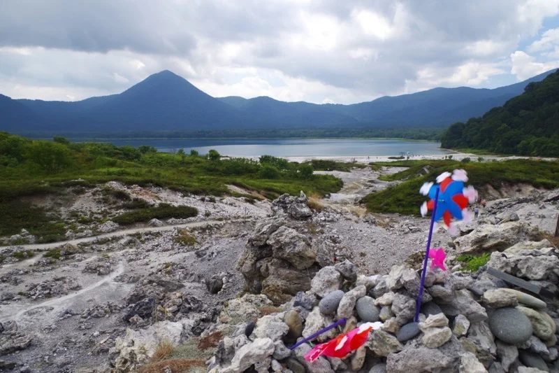
FactOsorezan is a volcano, and on the shores of its caldera lake, Usoriyama-ko, stretches a desolate rocky landscape where sulphurous fumes rise here and there. This area is likened to hell, while the white-sand lakeshore is called "Gokuraku-hama" (Paradise Beach). Among the rocks stand piles of stones heaped in memory of the dead, and pinwheels turning in the wind.
FactAt the summer grand festival (20–24 July) and other times, itako come to the mountain. These are folk mediums who perform kuchiyose, calling up the spirits of the dead and speaking their words. Itako are traditional shamans of the Tohoku region, mostly visually impaired women who became mediums after rigorous training. Today very few remain.
The Tonami domain: people from Aizu
FactDefeated by the new government's forces in the Boshin War of 1868, the Aizu domain was stripped of its lands. The following year the family was permitted to re-establish itself, but the new territory it was given centred on the Shimokita Peninsula. This is how the Tonami domain came into being.
FactIn 1870 the domain's samurai and their families, said to number about 17,000 people, moved here by sea and by land. But almost no crops would grow in the volcanic-ash soil, the winter cold was severe, and people suffered from hunger and cold. With the abolition of the domains in 1871, the following year, the Tonami domain ceased to exist, and many people left for Aizu and elsewhere.
FactShiba Goro, who lived in Tonami as a boy, later became an army general and wrote down his experiences of that time as a testament. This memoir has been published as Aru Meijijin no Kiroku ("Record of a Man of Meiji"; the Books room). Traces of the settlements founded by the Aizu people, and their graves, remain in Mutsu City.
Cape Oma, Hotokegaura and the Kandachime horses
FactCape Oma, at the northern tip of the peninsula, is the northernmost point of Honshu. On the cape stand a monument reading "Here is the northernmost point of Honshu" and a sculpture of pole-and-line tuna fishing, and on clear days the hills of Hakodate in Hokkaido can be seen across the Tsugaru Strait (the Food room).
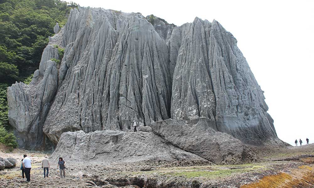
FactOn the peninsula's west coast lies Hotokegaura, where pillars of white and greenish rock stand in rows; it is designated a Place of Scenic Beauty and Natural Monument of Japan. At Cape Shiriya on the eastern tip you can meet the Kandachime, horses that are left out to graze even in the winter snow.
Look for this: the shape of the peninsula
The Shimokita Peninsula is shaped like a masakari, a broad axe. Ask someone from Aomori Prefecture "Where is Mutsu City?" and they may shape their hand like the axe and point to the spot on it. Look at a map and the shape makes perfect sense.
Main sources: Osorezan Bodai-ji / Mutsu City, "The History of the Tonami Domain" / Aizuwakamatsu City / Sai Village, "Hotokegaura" / Higashidori Village, "Kandachime Horses"