Ride the streetcar south from Odori toward Susukino and Nakajima Park, and you can feel the road climbing slightly. Central Sapporo was built on an alluvial fan—a fan-shaped spread of gravel the Toyohira River carried down from the mountains. Understand this landform, and spring-fed ponds, stone warehouses and onion fields all connect along a single line.
What is an alluvial fan?
A giant fan of gravel built by the Toyohira River
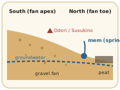
When a mountain river reaches flat land, it suddenly slows and drops the sand and gravel it has been carrying. Over long ages this spreads into a fan shape: an alluvial fan.
In Sapporo, the fan’s apex is where the Toyohira emerges onto the plain east of Mt. Moiwa, and it slopes gently north as far as Sapporo Station.
Gravelly ground drains superbly, making it ideal for houses and roads. Placing the capital on top of it was a sensible choice for the Meiji-era Development Commission.
North of the fan, by contrast, lay low wetlands where water gathered. The two theories about the name “Sapporo”—a “dry river” and a “river of reeds”—seem to describe the top and bottom of this very fan.
A line of springs
“Mem”—the springs at the edge of the fan
Water that soaks into an alluvial fan flows underground and resurfaces at the fan’s lower edge, or toe. The Ainu called such spring-fed ponds mem.
In Sapporo, a string of mem is said to have run roughly from southwest of today’s Sapporo Station to Hokkaido University.
The pond in the Hokkaido University Botanic Garden, the streams on the university campus, the garden of the Governor’s Official Residence, Kairakuen in Kita Ward (where the Seikatei pavilion, used by Emperor Meiji for a rest stop, still stands)…
Connect them on a map and a line appears along the toe of the fan. Meiji-era planners put gardens and official residences here because of the clean spring water.
Insider note
A stream that vanished—and came back
As urbanization lowered the water table, the mem dried up one after another. The Sakushukotoni River, which once flowed through the Hokkaido University campus, was one of them. In the 2000s it was revived by channeling water back in, and it is now a favorite spot for students and residents. As you walk the campus, think of it as a memory of the fan’s edge.
A gift from 40,000 years ago
A Meiji city built of volcanic stone
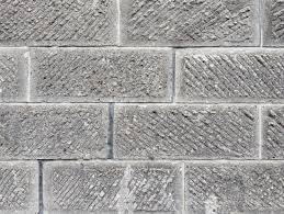
A wall of Sapporo soft stone, with diagonal chisel marks
About 40,000 years ago, a massive eruption occurred around what is now Lake Shikotsu, south of Sapporo. Huge pyroclastic flows poured down, some reaching today’s Minami Ward.
The thick layers of hot volcanic ash cooled and hardened into Sapporo soft stone (welded tuff).
Soft, easy to carve and fire-resistant, it caught the eye of foreign advisers in the early Meiji era, and the Development Commission encouraged quarrying. The quarry district is simply called Ishiyama—“stone mountain.”
The stone was used for warehouses, shops, churches and government buildings; surveys in the 2000s identified some 300 soft-stone buildings in the city.
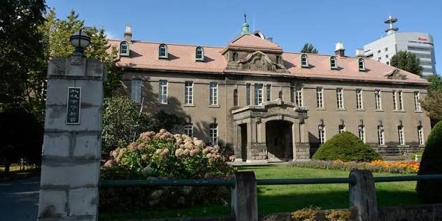
The Sapporo City Archives (the former Sapporo Court of Appeals) at the western end of Odori Park is built of it too.
Sapporo City Archives (former Court of Appeals, 1926), faced with Sapporo soft stone
Local know-how
Drive around Ishiyama and Fujino in Minami Ward and you’ll spot old soft-stone warehouses here and there. Quarrying declined once concrete blocks became common, and only a few quarry operators remain. Yet soft-stone bread ovens and homeware have become popular: the “40,000-year-old stone” is still in use, in new forms.
Beyond the fan
Northern lowlands, peat and onion fields
North of the fan, the land changes completely. The lowlands of the Ishikari Plain were covered with peat—layers of dead plants that never fully decomposed.
Poorly drained and soft underfoot, it was slowly turned into farmland by Meiji settlers who dug drainage ditches and brought in new soil.
One result is the onion long grown in Higashi Ward. “Sapporo Ki”, selected here over generations from a variety brought from America in the days of the Agricultural College, is now called a “phantom onion.”
The unruly Toyohira and the stream in Nakajima Park
The Toyohira River that built the fan was also prone to flooding. Its course shifted over time, leaving several former channels on the north side of the city.
The Kamokamo River flowing through Nakajima Park branches off the Toyohira and joins the Sosei River downstream. If you meet running water downtown, it may be a trace of the fan’s old waterways.
See it for yourself
Six places to feel the landform
Walk like a geography detective—pay attention to the height of the ground and the presence of water.
① South by streetcar
Susukino → Nakajima Park → toward Mt. Moiwa. The street outside rises gently toward the fan’s apex.
② The Botanic Garden pond
Once a mem spring. A fan-edge landscape survives in the middle of downtown.
③ Sakushukotoni River at Hokkaido University
A stream that disappeared and was restored, flowing north through campus.
④ Kairakuen and Seikatei
Why was a Meiji garden built here? Because of the spring water.
⑤ Ishiyama Ryokuchi
A former soft-stone quarry turned park—see the rock of the ancient pyroclastic flow up close.
⑥ Sapporo City Archives
Odori Nishi 13. Above the entrance of its soft-stone façade: a blindfolded Themis, goddess of justice, with sword and scales.
Read next
Who Drew the Grid?
A commissioner dismissed within half a year, a canal that became the origin of every address, and a firebreak that became a park.